For the past six years or so, crosswording has been one my hobbies. After starting with the easy ones in the local newspaper, I moved on to those in the NY Times. The NYT puzzles, edited by the noted enigmatologist and table tennis player Will Shortz, get more difficult during the week. For a few years I only did Monday and Tuesday, then added Wednesday, and gradually the rest of the week. Ok, I seek a little help (cheat) sometimes, just like in golf, but I've now solved over 1000 NYT puzzles, including the last 250 in a row.
Friday's puzzle had a clue that probably was difficult for some, but with one or two letters already filled on crosses, I immediately realized that for the clue at 16-across, "Experts in determining the exact size and shape of the earth," the answer was "geodesists."
 |
NY Times crossword of 11/20/20, including the 16-across clue for the answer "geodesists"
|
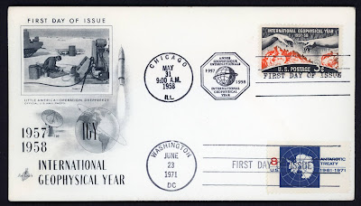
I took this as a sign compelling me to write today's entry, and to briefly describe the scientific scope of the IGY. There were 14 designated areas for scientific pursuits during the IGY. One source where the list is enumerated and described is in the book IGY: Year of Discovery, by Sydney Chapman (University of Michigan Press, Ann Arbor, 1959, 111 p.).
 |
My copy of IGY: Year of Discovery, by Sydney Chapman
|
In the chapter on The International Geophysical Year, Chapman, who was president of CSAGI (French acronym for the Special Committee of the IGY), lists these areas as:
- World Days and communications
- meteorology
- geomagnetism
- aurora and airglow
- ionosphere
- solar activity
- cosmic rays
- longitudes and latitudes
- glaciology
- oceanography
- rockets and satellites
- seismology
- gravity
- nuclear radiation
Of these, both #8 and #13 are used to determine the size and shape of the Earth, which comprises the field of geodesy. Until the IGY, few geodetic measurements had been made on Antarctica. During the IGY, new measurements there and elsewhere around the world refined our knowledge of the dimensions of our planet, which were soon detailed even further after the launch of satellites that orbited the Earth in accordance with its gravitational field.
Recently I bought a maxicard because of its relationship to geodesy, and also to my father. In philately, a maximum card (maxicard) is a postcard with a postage stamp on the back of the card where the stamp and card thematically match. The cancellation or postmark is usually related to the image on the front of the card and the stamp. Collecting such cards is the object of maximaphily, and also a specialty area of postcard collecting. This card bears a stamp in the form of a souvenir sheet, and a first day cancellation from Moldova, honoring the bicentennial of the initiation of the Struve Geodetic Arc survey. The terminus of the survey line in Moldova, marked by the monument shown on the stamp and on the maxicard, is a UNESCO World Heritage site.
 |
| Front and back of my Moldovan maxicard on the Struve Geodetic Art |
The maxicard's topic is the Struve Geodetic Arc. I hadn't previously known about this milestone achievement until I stumbled upon this card and stamp. The Struve Arc was a chain of survey triangulations stretching from Norway and then through 10 countries and over 2,800 km. It ends on the Black Sea after traversing what today is the country of Moldova. The survey, carried out between 1816 and 1855 by the astronomer Friedrich Georg Wilhelm Struve, represented the first accurate measuring of a long segment of a line of longitude. This helped to establish the exact size and shape of the planet and marked an important step in the development of Earth sciences and topographic mapping. It is an extraordinary example of scientific collaboration among scientists from different countries, and of collaboration between monarchs for a scientific cause. Thus, it presages the IGY-era study of the dimensions of the Earth as well as the international cooperation that was a hallmark of the IGY.
My father Morris Sternberg was born in Besserabia in 1906, later emigrating to the U.S. in 1927. At that time, Besserabia was in Romania. Not long before, it had been part of the Ottoman Empire, and not long after it became part of the Soviet Union. After the dissolution of the USSR, Besserabia became part of the country of Moldova in 1991. If I ever visit my father's birth region, I'll now hope to also visit the monument honoring the Struve Geodetic Arc.
Thanks to my cousin Mary Ann, who provided the photo of my father with her parents.
 |
My dad Morris (left), his brother Aaron (right), Aaron's wife Pauline (center), ca. 1941
|


