One thing I like about physics is how the same math and physics principles can be used to understand a variety of different phenomena. In a recent post I briefly reviewed the use of refraction and reflection of seismic waves for learning about the layering of the sea floor. Other types of waves that can be refracted and reflected include sound waves, light (waves in the visible part of the electromagnetic spectrum), and other types of electromagnetic waves.
I came across two interesting articles in the last few days about wave phenomena that I wanted to mention. So let's call today's post just a little bit of (geo)physics, maybe because I am too lazy to dig into the next IGY Bulletin article.
The first article appeared Tuesday in The Guardian, one of three newspapers I look at every day and financially support. (The other two are the New York Times and the local Lancaster LNP.) The article was about a mysterious "iceberg"that appeared off the coast of Vancouver Island, a sighting that was surprising because it had not been otherwise noticed.
Simone Engels’s photograph of the apparent iceberg off the coast of Vancouver Island (The Guardian, 25 Jan. 2022)
The photographer Simone Engels was actually seeing the Cheam mountain range on the mainland of British Columbia, nearly 125 miles away, and below the horizon from where she was standing. This optical illusion was caused by what is known as a “superior mirage” which can occur when there is an atmospheric temperature inversion with a band of warm air resting on a layer of cold air. In such a situation, light rays from the source object are refracted (bent), projecting an image into the "wrong" position. The temperature boundary of the inversion represents a discontinuity in terms of light velocity, so the light waves are bent and seen to be at ground level even though the object actually lies below the horizon.
The Italian term for such a superior mirage is Fata Morgana, and this video also explains and shows how it works: This is the opposite of an "inferior mirage." For example, when you drive on a hot day and see mirage “puddles” on the pavement, that’s basically a repeated image of the sky that’s bent into a visible spot on the ground.
An article in the Smithsonian Magazine from 2012 that I came across described the hypothesis that a superior mirage led to the sinking of the Titanic in 1912 and the more than 1500 deaths that resulted. According to this idea, a thermal inversion and corresponding optical distortion camouflaged the presence of the looming iceberg to those on the Titanic until it was too late, and then distorted the distress signals that the Titanic sent out to the nearby freighter Californian after it was hit.
As for a stamp that shows seismic reflection and refraction, the former German Democratic Republic (aka GDR, East Germany, or Deutsche Demokratische Republik -- DDR -- auf Deutsch) issued a set of four geophysics stamps in 1980. These stamps are what philatelists call "se-tenant": two or more stamps of different colors, designs or values that are printed adjacent to each other on one sheet. (The American and Swedish sets on stamp collecting showed in my recent posts were also se-tenant.) The German 35-pfennig (pre-Euro) stamp (Scott #2145) shows seismic waves that are both reflected and refracted by layers in the geologic subsurface, used for reconnaissance exploration of oil and natural gas deposits.
Cover from my collection showing GDR Scott block #2146a, including stamps #2143-2146, on the topic of geophysical exploration
In the next couple of months, I am involved in two events relating to my stamp collecting interests. Of course, my main interest is in the IGY (duh) and related stamps and covers. More recently I have also been collecting covers related to U.S. earthquakes. I would include both of these under the rubric of "geo-philately," or stamp collecting related to the geosciences.
One of the major professional geoscience societies is the Geological Society of America, with some 20,000 members. There is an annual national meeting, and also annual regional meetings. This year the Northeastern Section meeting is here in Lancaster, Pennsylvania. Several people associated with Franklin & Marshall College and Millersville University (and others) are on the organizing committee. I am in charge of workshops/short courses, and I'm also convening an online short course on geo-philately. Anyone, regardless of GSA membership, can participate. Since the workshop is online, you do not have to physically attend the meeting. I hope the workshop would have something to offer to established collectors, beginners, and people who are just curious. There will be two featured presenters, and short presentations from anyone else who would like to (time permitting). Here is a link with the current blurb for this workshop. Registration for the workshop can be done here.
Please contact me if you have interest or questions or suggestions for this workshop. You can leave me a comment via the blog, or send an email to rssternberg@gmail.com.
The second event is a presentation I will make on my IGY collection at a regular virtual meeting of the Philatelic Society of Lancaster County. I am scheduled for Wednesday, April 27, during the group's bimonthly meeting that lasts from 6:30-8:00 pm, Eastern time. The meeting is open to all, so see the web page for instructions on how you can join in to the Zoom meeting.
The description of the talk is as follows:
A Thematic Collection on the International Geophysical Year, 1957-58, by Rob Sternberg.
The International Geophysical Year (1957-1958) was an ambitious cooperative enterprise involving thousands of scientists from sixty-seven nations. A great variety of experiments and measurements were made on, above, and below the Earth's surface. The first artificial satellites were launched as part of the IGY, and there were coordinated and extensive scientific studies of Antarctica and the Arctic. Geophysicist Rob Sternberg will tell the story of the IGY through stamps, covers, and other related ephemera and memorabilia.
This IGY Bulletin article is based on material supplied by Henri Bader of the U.S. Army Snow, Ice, and Permafrost Research Establishment (SIPRE).
The major IGY effort in glaciology was directed towards the study of ice and snow in the polar regions, particularly the glaciers and ice sheets, not only to study ice behavior, but to yield data on climate.
As the Bulletin article points out, summer melt on the Antarctic and Greenland ice sheets is minimal, so annual layers of snow are preserved under later layers, and gradually compressed to ice. Extracting annual layers from pits can allow the determination of a chronology of ice layers, which then allows a time series of data on precipitation, contents of trapped atmospheric gases, volcanic ash, etc., within the ice pores. The first such pit was dug to a depth of 15 meters at Eismitte in the middle of the Greenland ice cap by Ernst Sorge in 1930. This was part of the last expedition of Alfred Wegener, who died during that venture. Wegener was trained as an astronomer, worked as a meteorologist and polar scientist, and formulated the first cogent hypothesis of continental drift.
SIPRE drilled through the Greenland ice sheet to a depth of 300 meters in 1956, and to 411 meters in 1957. By the mid-1960s, the Cold Regions Research and Engineering Laboratory (see below) had further cored to a depth of almost 1400 meters, dating back to about 100,000 years ago.
Equipment for deep core drilling was also delivered to Byrd station in Antarctica in October, 1957.
A more complete history of ice core drilling done before, during, and after the IGY is given in the 47-page document, The History of Early Polar Ice Cores, written by Chester C. Langway, Jr. for the U.S. Army Corps of Engineers in 2008.
That publication includes the following entry on the International Geophysical Year, focusing on Henri Bader who was responsible for the Bulletin article:
Henri Bader – the Swiss scientist who helped form SIPRE in 1949 – was a renowned expert on mining and snow, having co-written Snow and Its Metamorphosis, which argued that snow and ice contain geological secrets similar to rock. After the formation of SIPRE, Bader began open pit experiments in Greenland measuring ice strata using Sorge’s Law of Densification, which he had reduced to a mathematical formula.
In 1956, he and assistants Chester “Chet” C. Langway and B. Lyle Hansen continued experiments with ice drilling in Greenland, achieving 991- then 1,336-foot samples.
At the 1957 International Geophysical Year conference, Bader as a member of the National Academy of Sciences proposed extracting a deep ice core in Antarctica with a pilot project in Greenland. Due to the heat and friction caused by heavy oil drills damaging the ice cores, the CRREL team had to develop a thermal drill cooled with a trichloroethylene-based fluid and a vacuum that removed meltwater. Using National Science Foundation (NSF) funding, the team started drilling at Camp Century, Greenland, in 1961, reached bedrock in 1966, and reached bedrock drilling at Byrd Station, Antarctica, in 1968.
The International Polar "Year" of 2007-2009 was actually the Fourth IPY, following the First International Polar Year (1882–1883), the Second International Polar Year (1932–1933), and the IGY (1957–58) which was also the Third IPY. A number of stamps were issued for the Fourth IPY; I bought two joint postal portfolios of stamps issued by the countries of Canada, Denmark, Finland, Greenland, Iceland, Norway, Sweden, and the USA to honor the IPY. Below is a scan of the booklet cover, and the stamps from Greenland, including one showing ice coring. Jay Smith & Associates calls the souvenir sheets issued by these eight countries joint issues; in my last post I had suggested the missed opportunity during the IGY for a joint stamp issue.
Greenland stamp showing ice coring, Scott catalog #491 (2007), for the Fourth IPY
I don't think I ever knew that there was an underlying zany Cold War endeavor for which the important scientific work at Camp Century was partly a smokescreen. Camp Century was also an underground military base with its own nuclear reactor. Wired magazine puts it as follows:
long after Camp Century had been abandoned, it would come to light that the US military was proposing something called the Iceworm system: a nuclear arsenal of 600 ballistic missiles, trained toward the Soviet Union, which would be in constant motion by rail under the Greenland ice sheet. Iceworm was never built. The military soon understood that Camp Century was doomed. At best it would last 10 years, they acknowledged, at which point the overburden of snow would push down on the roof, compress the walls, and thus destroy it. [Duh, ice flows and deforms, as is known from glaciers.]
Camp Century was a perfect example of Cold War paranoia and eccentricity: an improbable outpost that was expensive to build, difficult to maintain, and unpleasant to live within.
I'd encourage you to read the Wired article, which presents some fascinating details about both projects at Camp Century. Henri Bader is cast in a less glowing light in this writeup. One moral of this story is that you can certainly suspect that whenever the U.S. Army or other service branch is coordinating a "research" program, there are likely some military motivations.
This British Channel 4 video summarizes this military aspect of Camp Century, and its environmental impact:
I closed the last post showing a postage stamp with a design about stamp collecting. This was part of a set of four stamps issued in 1986 by the U.S., Scott #'s 2198-2201. They were issued as a booklet of 4 stamps; this was the first time that U.S. commemoratives were ever issued in booklet form. The stamp honors the 100th anniversary of the American Philatelic Society. The place of issue was State College, PA (where Penn State University is located), which is near the present-day home of the American Philatelic Society in Bellefonte, PA.
What I own is a USPS official souvenir page, Scott catalog #SP741. It includes all four stamps, and shows the first-day of issue cancellation date of Jan. 23, 1986.
As usual, clink on the image for a larger version, where you can read the text.
These stamps were part of a joint issue between the U.S. and Sweden, the second time these two countries had done so. A joint issue involves stamps issued by two or more countries simultaneously, with similar designs, to commemorate the same (or related) people or events. For Sweden, 1986 marked the 250th anniversary of their post office and the 100th anniversary of the Swedish Philatelic Society.
Sweden stamp collecting issue booklet from my collection
StampData.com has a list of approximately 500 joint stamp issues. There were not any joint issues surrounding the International Geophysical Year, a seemingly excellent opportunity. The first U.S. joint issue was with Canada in 1956 for the opening of the St. Lawrence Seaway. The U.S. stamp Scott #1131 was co-designed by Ervine Metzl, the designer of the U.S. IGY stamp. Canada's stamp, Scott #387, had the same design. The U.S. has participated in about 40 joint philatelic issues.
From my childhood album
I am going to hang my Stamp Collecting souvenir page on (the inside of) my home office door along with a poster I bought from the American Philatelic Society:
Moving on now to the IGY Bulletinissue #7 (out of 96, remember!) from January, 1958. The download of this 16-page issue from the AGU website can be found here. The articles in this issue are:
Oceanographic expedition Downwind
Polar ice and snow studies
Rocket flare patrol program
Microcard program for IGY meteorological data
Ionospheric studies using Earth satellites
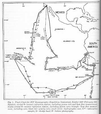
Here I will summarize the first article. Downwind was a major oceanographic expedition in the Pacific Ocean. It involved two research vessels, the Horizon and the Spencer F. Baird, both operated by the Scripps Institution of Oceanography. These research vessels were converted tugs, each with a lab space of 600 square feet, a crew of 17, and room for 15 scientists. They had A-frames and winches capable of lifting loads of 20 tons.
The Downwind expedition was to make a number of geophysical observations, including seismic refraction studies to examine oceanic crustal structure, heat flow measurements, and collection of core samples. It was an extension of previous Scripps expeditions in the Pacific. The approximate track of the expedition is shown in the figure below, from the Bulletin article.
The article includes a summary of early work in the expedition by noted geologist H.W. Menard, co-leader of the expedition. Photographs of the sea floor at depths of over 14,000 feet, deepest yet in the Pacific, showed evidence of biological activity. Seismic reflection work revealed sediment thicknesses of over 1000', overlying crust of typical structure as inferred by seismic refraction. Atmospheric carbon dioxide levels of 310 ppm were measured; because of anthropogenic carbon emissions, the current atmospheric level of CO2 is now about 420 ppm, one-third higher!
I thought a very brief explanation of seismic refraction and reflection methods might be in order here, since these methods will crop up from time to time in discussing IGY studies. These are two of the major geophysical methods of inferring the nature of the Earth's subsurface, both in terns of grosser crustal structure and also finer details such as might be useful in the search for oil. Seismic refraction studies can determine depths to geologic boundaries and the seismic velocities of layers. These are inferred from so-called "head waves" which refract, or bend, to travel along the boundaries between lower-velocity and higher-velocity layers. Seismic reflection can also map out seismic (hence geologic) discontinuities by echoing seismic waves from them. Seismic surveys can be done on land, or as with Downwind, at sea.
Marine seismic surveys: Explosive charges generate waves that reflect (bounce) off contrasting layers, and that refract (bend) along boundaries between contrasting layers, before being measured by hydrophone sensors (CoastalReview.org )
Perhaps a bit tangential to this post (which rarely stops me), I was interested to learn that the eponymous Spencer Fullerton Baird (1823-87) was quite an accomplished individual: he was
a naturalist, professor, first curator of the National Museum at the Smithsonian in 1850, second Secretary of the Smithsonian (1878-87), secretary of the American Association for the Advancement of Science, and first Commissioner of the United States Commission of Fish and Fisheries. He oversaw construction of the U.S. National (Smithsonian) Museum which opened in 1881. He has roots local to my area, having been born in Reading, PA, and educated and later professor at Dickinson College in Carlisle, PA. Baird was an avid stamp collector who bequeathed to the U.S. National Museum his collection of 1,733 foreign postage stamps gleaned from his prodigious personal correspondence. The loupe shown in the upper left of U.S. Scott #2198 belonged to Baird, and is now part of the Baird memorabilia in the Smithsonian Museum of American History (Revinus, 1989).
Scott #2198 (1986), including depiction of a loupe owned by Baird, part of a set of four stamps about stamp collecting, from a USPS souvenir page in my collection that I will show in another post
When working on yesterday's post, I forgot to check my cover albums to see if Laika was lurking there. During the night I recalled that I had two first day covers of the 1957 Sputnik 2-Laika stamps from Romania. The scans are below. Cancellation dates are Dec. 20, 1957, the date of issuance of the stamps (as you would expect for a first day cover). The top cover is postmarked from Timasoara, which is the main economic, social and cultural center in western Romania. Bucharest, the capital and largest city, is in the southeast. I can't make out the postmark location on the second one. Both covers have cachets denoting the IGY/Geophysical Year, and both denote orbits, the top one suggesting electrons orbiting an atomic nucleus, the bottom one clearly showing a satellite orbiting Earth.
This issue of the IGY Bulletin closes with a short piece on the launch of Sputnik 2 on Nov. 3, 1957. The text issued by the Russian news agency Tasswas included verbatim. It stated that the satellite was instrumented to measure solar ultraviolet radiation and x-rays, cosmic rays, temperature, and pressure. Data were transmitted to Earth via radio waves for a week after launch.
This satellite project was giving the go-ahead after the successful launch of Sputnik 1, and was completed within a month to launch in time to honor the 40th anniversary of the Russian Revolution.
Sputnik 2 weighed 1100 pounds, about six times as much as Sputnik 1. Clearly, the Soviet rockets were able to carry significant payloads. Sputnik 2 stayed in orbit through April 14, 1958, when it burned up in the atmosphere. It completed 2,370 revolutions around the Earth.
Sputnik 2 also carried the first animal into orbit, the dog Laika, as described in this article on the 60th anniversary of its launch. The Soviet Union had already gained experience in launching animals via rockets into the stratosphere. Laika had implanted gauges for measuring blood pressure, respiration, and tracing of electrocardiograms. Laika was doomed to die since there was no way at that time to return to Earth. She survived the launch, but it was revealed years later that she died not long afterwards due to excessive heat. Laika's fate stimulated some of the early protests for animal rights.
November 13, 1957. Dog Laika in a hermetic cabin before installation on the satellite (Tass)
I own a 52-page booklet entitled Soviet Sputniks, published during the IGY in 1958 by Soviet News as booklet #25. It focuses on the basics of the Soviet satellite program, and specifically on Sputniks 1 and 2.
Scan of cover of Soviet Sputniks
The booklet contains a figure showing the biological monitoring of Laika.
I was inspired by this dog's tale (not her tail) to order the eponymous prize-winning graphic novel Laika, published in 2007 by Nick Abadzis.
Images from the graphic novel have also been set to music by Luca Tozzi in this video.
The Sputniks have been well represented on stamps. The Soviet Union issued a set of four stamps in 1957 and 1958 (Scott #2032-2036) honoring Sputnik 2, depicting the allegorical statue "To the Stars" by artist and sculptor Yevgeny Vuchetich.
Russia Sputnik 2 stamps (Scott #2032-2036) from my collection
Laika, the "first space traveler," was commemorated earliest along with Sputnik 2 on two Romanian stamps (Scott #1200-1201) issued on Dec. 20, 1957.
Romania Sputnik 2-Laika stamps (Scott #1200-1201) from my collection
I just returned from three weeks of family vacation. I thought I would summarize the last article in the December 1957 IGY Bulletin before I left, then I thought I'd do it while I was away, but I just ended up taking a break. So that post will come in the next couple of days.
Today is Martin Luther King Jr. Day in the U.S., honoring the birthday and legacy of the civil rights leader. King. By the time of the IGY in 1957-58, the 28 year old King had already played a leadership role in the Montgomery bus boycott (1955) and was a co-founder of the Southern Christian Leadership Conference (1957). The IGY may have been a time of international scientific cooperation, but there was also plenty of domestic strife over issues of racism, economic inequality, and civil liberties.
Two U.S. stamps have been issued in King's honor. I don't own either, but I scanned images from my recently purchased Harris U.S. Postage Stamp Catalog. I didn't really need the book, but after looking at it in the public library I couldn't resist the tactile and visual appeal of those glossy pages and pictures.
Cover scan of my catalog
Martin Luther King Jr. commemorative, 1979, Scott #1771
MLK stamp (Scott 3188a, 1999), part of the 1960s Celebrate the Century sheet
I visited the King Center during the Society for American Archaeology annual meeting in Atlanta in 2009.
Martin Luther King Jr. and Coretta Scott King burial monuments, King Center, Atlanta
Anyway, the recent vacation took the four of us to Germany to visit family, and then to Gran Canaria (Spain, but off the west coast of Africa) for two weeks of sunshine and relaxation. We bought our tickets before the onset of Omicron, so we went ahead and took the risk. We avoided indoor crowds, and thankfully made it back ok.
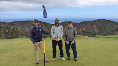
The geology of the island provided a dramatic background to the trip. The seven major islands of the Canaries archipelago are volcanic in origin, formed atop a hotspot in the Earth's mantle as the African tectonic plate drifted over the stationary hotspot, similar to the formation of the Hawaiian Islands. (The idea of hotspots was not yet understood in the pre-plate tectonic days of the IGY.) The Cumbre Vieja volcano on the westernmost island of La Palma, currently over the hotspot, has been recently active and in the news. We stayed near the Bandama Caldera for a week, hiked around it, and even played golf adjacent to it. I didn't play that well, but lost no balls into the caldera or anywhere else during my 9 holes.
My photo of Bandama Caldera, with Pico de Bandama in the background
Max, Sam, and myself with the Bandama Caldera behind us at the Real Club de Golf de Las Palmas
The day we moved down to the south coast for another week, we left cooler and cloudy weather behind on the north slope of the central highlands (orographic effect). We did get a lot of wind as we walked a ways into the Maspalomas sand dune area, but at least the wind seemed to keep away the naked hordes that apparently frequent this area.
My photo of the Maspalomas sand dunes
Sunrise from Bandama
I did think a little about celestial orbits on the trip. We watched sunrises from our patio in Bandama the first week, and the second week Max started a golf round before sunrise at the Anfi Tauro golf club. I was surprised to realize that in early January, sunrise was still occurring slightly later each day, even though the shortest day of the year in the northern hemisphere had already occurred at the solstice on Dec. 21. And here is the explanation why! In early January, at 20°N latitude, the sunrise gets slightly later, but so does the sunset, such that the days do indeed become longer.
Times of sunrise and sunset. Gran Canaria is near 20°N latitude.
On the flight home, one of the two movies I watched was Jailhouse Rock, with Elvis Presley. It was released in the Fall of 1957, so it is an IGY era movie. I hadn't seen it in many years. It is light fare, and pretty standard bad boy-makes-good movie, but Elvis and his music were endearing enough. The title song was well choreographed, and Elvis' gyrations elicited an appreciative laugh from me: