Sunday, February 27, 2022

IGY Bulletin, Number 7, January 1958 - Ionospheric studies using Earth satellites

This is a summary the last article from the January 1958 issue of the IGY Bulletin.

By the end of January, 1958, three satellites had been successfully launched: Sputnik 1 (launched Oct. 4, 1957), Sputnik 2 (Nov. 3, 1957), and Explorer 1 (Jan. 31, 1958).

The article starts by stating that a conference on the study of the ionosphere by using radio observations of satellites was help on Nov. 5, 1957 (just after the launch of Sputnik 2), at the Central Radio Propagation Laboratory of the National Bureau of Standards (now the National Institute of Standard and Technology), under the direction of Alan H. Shapley.

Twelve projects that had utilized radio observations of Sputnik 1 are tabulated in the article.

The article is fairly dry, but a good summary of how Sputnik 1 could be used to infer ionospheric properties is given in: Sputnik 1 and the First Satellite Ionospheric Experiment, a poster co-authored by V. D. Kuznetsov (Pushkov Institute of Terrestrial Magnetism, Ionosphere and Radio Wave Propagation) as a contribution to the 40th COSPAR Scientific Assembly, August, 2014. His explanation is as follows:

Any luminous body such as an artificial satellite, moving along a closed orbit around the earth, becomes optically visible at an observation point on the earth’s surface when it rises above the horizon at that point. The rays of visible light propagate in the atmosphere and space on a nearly perfectly straight path. The moving body optically disappears, at the same observation point, when the body falls below a straight line to the opposite horizon. ... The propagation paths of the radio waves emitted by satellite, however, are curved [refracted] in the ionosphere, that is, in the ionized part of the atmosphere where free electrons and ions are produced. ... The curvature of the radio waves' paths becomes appreciable at altitudes of 60-70 km above the surface of the earth; it is greatest at about 250-350 km, and disappears at about 1000-1500 km, where the paths of the waves ... are approximately straight. Therefore, the radio appearance of a satellite precedes its optical visibility. Similarly, in disappearing from view, the radio disappearance of the satellite is late with respect to the disappearing optical view. This effect depends upon the ionization level of the ionosphere and, in particular, on the altitude distribution of the density of free electrons and ions, which are produced in the atmosphere by ultraviolet solar radiation [emphasis mine]. Therefore, to determine the times of the rise and set of the radio signal, it is necessary to know the altitude dependence of the electron density in the ionosphere. On the other hand, if you know these times and the position of the body, and if you also have some initial data, that is, some characteristics of the ionosphere at that time, you can find the average, smoothed altitude dependence of electron concentration [emphasis mine].

From Kuznetsov (2014). The position labeled O on the Earth's surface is the observation point. Note that the optical set points are on the horizon, while the radio set points are below the horizon.

This is similar to the phenomenon of the Fata Morgana discussed in a previous post.

In my collection, I have a 1959 issue of the Proceedings of the Institute of Radio Engineers, the cover of which is shown below.


Articles in this issue related to IGY studies of the ionosphere 

Article authors include IGY luminaries Lloyd Berkner, Sydney Chapman, and Marcel Nicolet.

In the preface, guest editor Millett G. Morgan describes the issue as follows: 
The issue opens with a guest editorial by L. V. berkner. The first papers describe the undisturbed ionosphere, and the succeeding ones, the severe disturbances which are produced by solar flares. Following these are
papers describing rocket and satellite measurements in both the undisturbed and the disturbed ionosphere. As an addendum, papers have been added describing some of the special purpose radio equipment used in making ionospheric measurements, and the global system of warning and communication developed for the IGY. 

Friday, February 25, 2022

Two stamps from the Ukraine

I was away for a week in Florida (I'll include some photos in a couple of posts). And this week I have been busy with other things. But before I return to the IGY proper, today I am thinking of Ukraine.

So I bought two stamps to give some philatelic tie-in to my unhappiness at what is going on there. The first is a souvenir sheet (with simulated perforations) commemorating Independence Day of Ukraine, showing a map of Ukraine against the background of the globe, a rainbow of national colors and viburnum bushes in the form of a festive fireworks. Just like the collaborators during the IGY, Ukraine is one country among many in the world. 

Scott #194, issued Sept. 3, 1994 (colnect.com)
 
The current form of the Ukrainian Independence Day holiday was first celebrated in 1991, as the first anniversary of the Declaration of State Sovereignty of Ukraine passed by Ukraine's parliament in 1990.

In Ukraine, the flowering plant Viburnum opulus is an important element of its traditional folk cultures, and is seen as a national symbol. 

On the other stamp I bought, Ukraine honored the World Meteorological Organization, about which I recently posted. This stamp commemorated the 50th anniversary of the founding of the WMO. The work of this organization was very connected to the meteorological studies of the IGY.

Scott #378, issued March 10, 2000 (colnect.com )

Solidarity with the people of the sovereign nation of Ukraine.

Wednesday, February 09, 2022

More on macrocards

For some reason, the microcards that were discussed in yesterday's post really intrigued me. I contacted one of Franklin & Marshall College's very helpful librarians, Tom Karel. He told me that the College library did house some microcards. I went over today, and entered a room I suspect is not much used anymore, housing microfilm, microfiche, and yes, some microcards. Wikipedia discusses these technologies in an article on microforms, which says "Three formats are common: microfilm (reels), microfiche (flat sheets), and aperture cards. Microcards, also known as 'micro-opaques', a format no longer produced, were similar to microfiche, but printed on cardboard rather than photographic film."

Here is the shelving for the microcards at F&M, maybe about 50 linear feet, about 150 boxes. (The orange/yellow/gray volumes in the lower right are not microcards.)


Each bound bound carton looks like this:

Almost all of F&M's microcard holdings are of the Landmarks of Science (Series 1), formerly produced by the University of OklahomaThis case contains work of James Hutton (1726-1797), the founder of modern geology. 

One slipcase can hold about 200 microcards. So the 150 boxes at F&M could hold about 30,000 microcards. This is about 50% more than what was needed for storage of the the IGY meteorological data, as mentioned in my previous blog post.

One Landmark of Science microcard looks like this:

First microcard of James Hutton's Theory of the Earth

Each card is 4" x 6", and contains 100 pages of text. So the 30,000 microcards in F&M's collection would be equivalent to about 3,000,000 pages. 

The pages are too small to read with the naked eye off these cards. But F&M still has a functional card reader, a Readex Microprint Opaque Viewer. (Readex now seems to specialize in offering collections of digitized online primary source research materials.)


The first page of Hutton's Theory of the Earth (1788) looks like this when magnified on the reader screen:

Of course, now we can find the text of this historic work online. Who would've imagined?

Monday, February 07, 2022

IGY Bulletin, Number 7, January 1958 - Microcard program for IGY meteorological data

This article was a report by D.A. Davies, Secretary General of the World Meteorological Organization.

As a specialized agency of the United Nations, WMO is dedicated to international cooperation and coordination on the state and behaviour of the Earth’s atmosphere, its interaction with the land and oceans, the weather and climate it produces, and the resulting distribution of water resources (WMO).

The WMO was established in 1950. Its interests were quite related to some of the goals of the IGY. The WMO Bulletin, volume 58. #1 2009, recalled its statement about the IGY from 50 years previously:

At the close of the International Geophysical Year (IGY), we would like to express, on behalf of the World Meteorological Organization, thanks and appreciation to all meteorological services of the world for their whole-hearted collaboration in this vast project, which provides yet another demonstration of the international spirit for which meteorologists have long been renowned. A special tribute must be paid to the thousands of meteorological observers throughout the world upon whom the IGY imposed many additional duties. We are confident that the same enthusiastic support will continue until the last of the forms containing the meteorological observations has been received at the WMO Secretariat, thus completing the collection of data which constitutes a unique contribution to future developments in the science of meteorology.

Signed:
A. Viaut, President
D.A. Davies, Secretary-General

Anyway, the Bulletin article goes on to say that the IGY Meteorological Data Centre, located within the WMO, was to publish the essential meteorological data collected during the IGY on "microcards," sensitized 3x5 inch cards on which printed matter was reproduced photographically in greatly reduced form. A special microcard reader could project an enlarged image so that the data could be read.

Microcards were an opaque positive microform, designed by Fremont Rider, librarian at Wesleyan University, in the early 1940s. He designed the microcard to serve as both a catalog card (front of card) and storage medium (reverse, containing up to 250 pages worth of microtext),in order to save shelf space in rapidly growing library collections. Microfiche appeared in the 1960s and supplanted microcards as the standard flat sheet microform (Jamison, 1988).

There were to be four types of IGY microcards recording different types of weather-related data:

  1. Surface observations made on land
  2. Surface observations made at sea
  3. Radiosonde and rawinsonde observations (see previous post)
  4. Upper wind observations

The Bulletin article estimated that about 18,500 microcards would be required to hold the essential meteorological observations of the IGY. A subscription price of $5,900 was established for a compete set of microcards. Today that would be equivalent to an inflation-adjusted $60,000.

Data storage has changed just a bit (pun intended) since the time of the IGY!

Sunday, February 06, 2022

IGY Bulletin, Number 7, January 1958 - Rocket Flare Patrol Program

This next article in the IGY Bulletin points out that several rockets were launched in July and August of 1957 to collect data on solar X-rays during times of solar flares. These missions were part of the Rocket Flare Patrol Program. (I can't find ANY links for this program online!)

I've mentioned solar flares in this previous post and this one also.

Here is a short NASA video tutorial on solar flares:


The Rocket Flare Patrol Program was designed to learn more about radio fadeouts caused by solar flares. Thirteen DAN program rocket flights that were sent up after solar flares were observed are listed in the Bulletin article. Altitudes ranged from 2 to 50 miles above the Earth's surface. The article goes on to describe some of the underlying ionospheric physics, rocket technology, and early results of this program, although I won't delve into these details. The program was conducted by the Naval Research Lab directed by the eminent physicist and space scientist Herbert Friedman; this blog post from the American Philosophical Society Library summarizes his scientific accomplishments as well as discussing the conservation of some of his medals in the collections of the APS.

According to this web page from the Stanford Solar Center, the Earth's ionosphere is composed of three main parts: the D, E, and F regions, ranging from about 50-150 miles above the Earth's surface. 

Earth's atmosphere and ionosphere (Stanford)

The ionosphere is of major importance to us because it influences radio wave propagation across distances. The ionosphere and the ground produce a “waveguide” through which radio signals can bounce back and forth, making their way around the curved Earth.  At night, without ionization by normal solar radiation, the D layer disappears, leaving the ionosphere with only the E and F layers. So radio waves from Earth echo back from these higher layers, and travel further around the Earth. That's why people on the East Coast can sometimes pick up night-time baseball game radio broadcasts from teams in the Midwest.

Radio wave propagation in the waveguide between the Earth's surface and the ionospheric D layer (Stanford)

When a solar flare occurs, the flare’s enhanced X-ray emissions (by a factor of ten or more according to the DAN program) compared to more quiet solar conditions cause an increase in the ionization of all the ionospheric layers, including the lowermost D. The ion content of D now becomes abundant enough to reflect the radio waves from a lower altitude. So during a solar flare, the waves travel a shorter distance by bouncing off D instead of E or F. Thus a so-called sudden ionospheric disturbance (SID) results from the abnormally high ionization density in the D region resulting from solar flares. The SID also causes an increase in radio-wave absorption (called radio fadeouts in the Bulletin article) which often interferes with telecommunications systems.

Space weather and its effects on our technological systems has become an increasingly important area of study since the IGY, especially as we have moved into the age of satellites and telecommunications.

Tuesday, February 01, 2022

64th anniversary of the successful launch of Explorer 1, America's first satellite

We've already talked in earlier posts about the successful launches of Sputnik 1 and Sputnik 2, and the failed launch of Vanguard TV3.

On this date, Jan. 31, in 1958, the U.S. successfully launched its first satellite, Explorer 1, into orbit. Much credit was given to the team of: William H. Pickering, director of the Jet Propulsion Laboratory which built and operated the satellite; James A. Van Allen, physicist at the State University of Iowa who designed and built the instrument on Explorer that discovered the eponymous radiation; and Wernher von Braun, leader of the Army's Redstone Arsenal team which built the first stage Redstone booster that was part of the Jupiter C rocket that carried Explorer 1 into space. The Army had replaced the Navy as the developer of the rocket after the failure of Vanguard TV3, a coup for the ambitious von Braun.

William Pickering, James Van Allen and Wernher von Braun (NASA)

This short JPL video summarizes the preparation, launch, and celebration of Explorer 1:


Explorer 1's orbit had a perigee of 220 miles and an apogee of 1,600 miles. It made one orbit every 115 minutes. The satellite weighed 30 pounds, and was 80 inches long, the same (or similar) size as the model shown in the upstretched arms of the men above. Explorer 1 made its final transmission on May 23, 1958. It entered Earth's atmosphere and burned up on March 31, 1970, after more than 58,000 orbits. 

The U.S. did not initially issue a stamp commemorating Explorer 1. I had speculated to myself that the U.S. did not want to highlight this great accomplishment because it was beaten into space by its Cold War rival, the Soviet Union. This was confirmed for me by Matin Modarressi, who I mentioned in a previous post. Matin sent me the link to this document from the Operations Coordinating Board (OCB), dated on Oct. 8, 1958, signed by CIA director Allen Dulles. It states in item #3 that

A suggestion by the Army was then brought up having to do with the possibility of a commemorative postage stamp in honor of the launching of Explorer 1. The majority of the Board felt that it might be unwise to issue such a stamp in view of the obvious disparity which now exists between our accomplishments in the satellite field and those of the USSR.

Fascinating! Also present at that OCB meeting was Abbott Wasburn, mentioned in earlier posts as Deputy Director of the United States Information Agency and a member of the Citizens' Stamp Advisory Committee and also as the head of public relations for General Mills, which was involved in Cold War biological warfare. I am so grateful that Matin shared this with me. 

Matin has a very interesting presentation about The Role of Stamps in U.S. Foreign Relations:


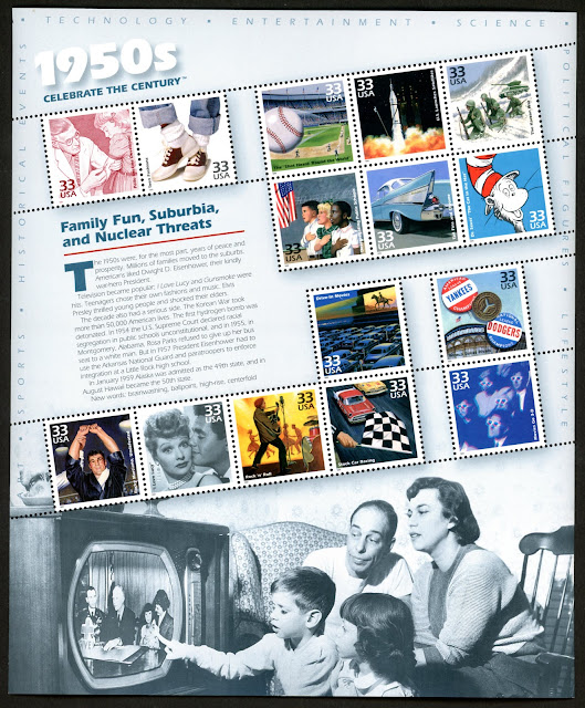
Finally, in 1999, Explorer 1 got its philatelic due, as part of the series of 10 sheets with the theme of Celebrate the Century:

Scott catalog #3187d (1999), Explorer 1

Obverse of Scott catalog #3187d

From my collection - Celebrate the Century: 1950s, Scott catalog #3187, with 15 se-tenant stamps

There have also been IGY covers issued on various anniversaries of the Explorer 1 launch. I showed one with a cachet in an earlier post, with Van Allen's signature. I'll show a few more when I review the IGY Bulletin article on Explorer 1 in its March 1958 issue. 

I am currently watching on PBS the new adaptation of Around the World in 80 Days. It's different from both the original 1872 novel by Jules Verne and the 1956 (IGY-era) film adaptation

starring David Niven, Cantinflas, and Shirley MacLaine, complemented with a slew of cameo appearances (including flamenco legend José Greco, who was a visiting professor here at Franklin & Marshall College in the last few years of his life). I saw the film (which won the Oscar for Best Picture of the year) as a youngster, and just re-bought a related book that I had owned for many years after we bought it at the movie theater so long ago.

I am now also re-reading -- after maybe 55 years -- Verne's novel (a free Kindle version is available on Amazon). I was thinking that the latest film adaptation was unfaithful to the book. Then I realized that the hot air balloon trip over the Alps in the new adaptation was also in the 1956 movie but was not in the book, so faithfulness is, well, relative. Anyway, the current adaptation is a new version of the story for a new era, and that's fair enough. I can't help but think that the 1956 movie was made at such a time as to be envisioning the imminent satellite journeys around the Earth. Those newest circumnavigations would take only two hours, about 1000 times faster than Phileas Fogg's trip around the world in 80 days.