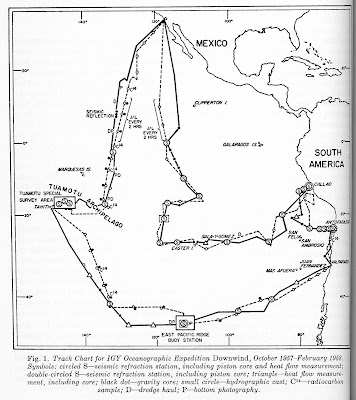
- Oceanographic expedition Downwind
- Polar ice and snow studies
- Rocket flare patrol program
- Microcard program for IGY meteorological data
- Ionospheric studies using Earth satellites
Here I will summarize the first article. Downwind was a major oceanographic expedition in the Pacific Ocean. It involved two research vessels, the Horizon and the Spencer F. Baird, both operated by the Scripps Institution of Oceanography. These research vessels were converted tugs, each with a lab space of 600 square feet, a crew of 17, and room for 15 scientists. They had A-frames and winches capable of lifting loads of 20 tons.
 |
| Research vessel Spencer F. Baird (Scripps) |
The Downwind expedition was to make a number of geophysical observations, including seismic refraction studies to examine oceanic crustal structure, heat flow measurements, and collection of core samples. It was an extension of previous Scripps expeditions in the Pacific. The approximate track of the expedition is shown in the figure below, from the Bulletin article.
The article includes a summary of early work in the expedition by noted geologist H.W. Menard, co-leader of the expedition. Photographs of the sea floor at depths of over 14,000 feet, deepest yet in the Pacific, showed evidence of biological activity. Seismic reflection work revealed sediment thicknesses of over 1000', overlying crust of typical structure as inferred by seismic refraction. Atmospheric carbon dioxide levels of 310 ppm were measured; because of anthropogenic carbon emissions, the current atmospheric level of CO2 is now about 420 ppm, one-third higher!
You can find photographs and a 60-page preliminary report of the results of Downwind here.
I thought a very brief explanation of seismic refraction and reflection methods might be in order here, since these methods will crop up from time to time in discussing IGY studies. These are two of the major geophysical methods of inferring the nature of the Earth's subsurface, both in terns of grosser crustal structure and also finer details such as might be useful in the search for oil. Seismic refraction studies can determine depths to geologic boundaries and the seismic velocities of layers. These are inferred from so-called "head waves" which refract, or bend, to travel along the boundaries between lower-velocity and higher-velocity layers. Seismic reflection can also map out seismic (hence geologic) discontinuities by echoing seismic waves from them. Seismic surveys can be done on land, or as with Downwind, at sea.
 |
| Marine seismic surveys: Explosive charges generate waves that reflect (bounce) off contrasting layers, and that refract (bend) along boundaries between contrasting layers, before being measured by hydrophone sensors (CoastalReview.org ) |
Perhaps a bit tangential to this post (which rarely stops me), I was interested to learn that the eponymous Spencer Fullerton Baird (1823-87) was quite an accomplished individual: he was
a naturalist, professor, first curator of the National Museum at the Smithsonian in 1850, second Secretary of the Smithsonian (1878-87), secretary of the American Association for the Advancement of Science, and first Commissioner of the United States Commission of Fish and Fisheries. He oversaw construction of the U.S. National (Smithsonian) Museum which opened in 1881. He has roots local to my area, having been born in Reading, PA, and educated and later professor at Dickinson College in Carlisle, PA. Baird was an avid stamp collector who bequeathed to the U.S. National Museum his collection of 1,733 foreign postage stamps gleaned from his prodigious personal correspondence. The loupe shown in the upper left of U.S. Scott #2198 belonged to Baird, and is now part of the Baird memorabilia in the Smithsonian Museum of American History (Revinus, 1989). |
| Scott #2198 (1986), including depiction of a loupe owned by Baird, part of a set of four stamps about stamp collecting, from a USPS souvenir page in my collection that I will show in another post |


No comments:
Post a Comment